
Historic Hood River
Spring Cleaning
3-5-2018
Notes

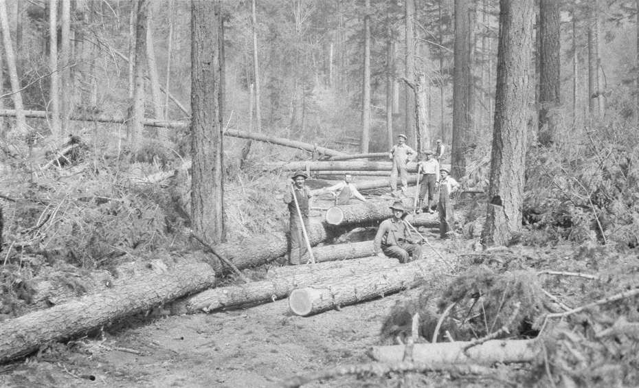
Springtime here means time to clean up the winter damage to all the roads and trails. Here’s Alva Day’s documentation of the cleanup from the winter of 1930-31. I’m guessing this is the road to Lost Lake.
I don’t think it will take long for nature to reclaim all these forest roads when we stop maintaining them.

Charlott
A good example of reclaiming land that was once a road is the old wagon road from Cooper Spur to Cloud Camp. Portions are still visible and at least in past times the old wagon road came in handy to go to Cloud Camp in the winter. Portions have gone back to nature. What I remember most were the cut through roads going to Cloud Cap when I was growing up. They were fun.
L.E.
A couple of chain saws would sure be a big help.
Being somewhat familiar with the forests of interior British Columbia, blowdowns like this were not uncommon. Sometimes it was easier to just cut a new road around the mess, sometimes a horse and rider would jump logs and try to continue on, but soon found themselves in a real mess that was hard to get out of.
Looking for blazed trees that mark the route can become a real puzzle solver.
It is amazing how quickly new trees will sprout up in the middle of an unused road. Often times in aerial photos the road will remain visible, but that doesn’t help if you are on the ground.
Kenn
I believe some of the old road below Cloud Cap is kept cleared for skiing ~
tom
The old Wagon Road is semi-maintained below Cloud Cap down to the northern most leg of the CC road. Skiable when there is enough snow to cover the downed trees. Below that it is virtually non-existent. I tried to ski the lower section north of the CC road yesterday and lost all resemblance of the trail after about 25 meters. Thanks to GPS technology, I was able to make my way back to road 3511 with much effort.
Judy
I love your take on this picture, L.E. I learn new things everyday especially about logging practices.
Longshot
I agree with Tom that the old road below the lowest leg of CC road heading off towards the Mt Hood Lodge has pretty much totally disappeared. Tried to walk it when the snow was gone and there was just nothing to follow, no ruts, no breaks in the trees. Whether through older forests or through newer clearcuts the route just can’t be found from the top. Have wanted to give it a try for the lower end someday.
L.E.
I hadn’t thought about they might actually be logging. My first thought was blow-down, but maybe not.
Ranger
If this was a logging operation, the foreground trees were "felled to lead", that is the were dropped in the direction that they would be skidded out. But the trees in the background are crossways to the skid road and would have to be bucked shorter to be able to be pulled out. It looks like the reopening of the road after a winter storm to me.
Arthur
Should have mentioned this is part of a series which seems to be documenting storm damage. Some of the other shots show the road better but I thought this one was more fun. No evidence of a logging operation, didn’t see anything to indicate salvage but i might have missed it.