
Historic Hood River
Rooster Rock
1-13-2021
Notes

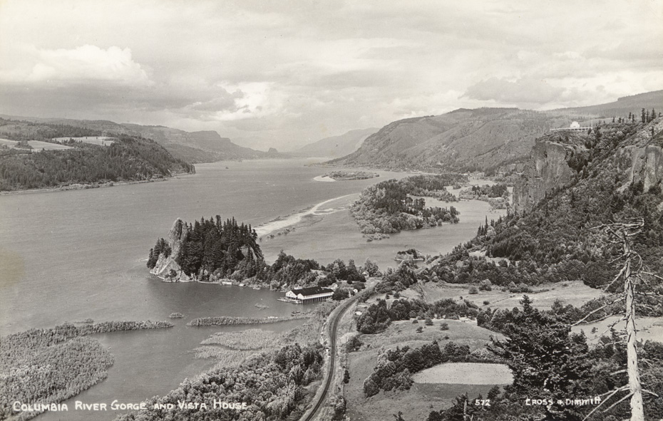
This Cross and Dimmitt postcard offers a great view of Rooster Rock and Crown Point. It you’ve ever wondered about those pilings in the Columbia just west of Rooster Rock, here is a clear view of the cannery which used to be located at that spot. This view of Vista House shows how clever the road engineers needed to be to descend from this point back down to the river level.
Category: default
Tags: Columbia River Highway, Cross and Dimmitt, railroad, Rooster Rock, Vista House
Tags: Columbia River Highway, Cross and Dimmitt, railroad, Rooster Rock, Vista House

Nellie
Many don’t realize just how many canneries were up and down the river. Many in every nook and cranny. That can give one an idea of the volume of salmon in that river in that era.
Look at all that area east of Rooster Rock that was a portion of the river. I can only assume that some of that area which is now land was due to the construction of Bonneville, holding water and lowering river level.
L.E.
My dad was born on those hills across the River
L.E.
I have read that Rooster Rock had more of a prominent "beak" when the first settlers came to the area, but I have never seen a photo of that.
kmb
What year would this be? Is the date given somewhere, am I missing it? I see train tracks but no road – does this mean it is before the highway was put in? Or was the original highway off to the right in this photo?
nails
What was the date of the building on Crown Point?
Norma
I can remember before i84 was built in the 50s that a trip to Portland took 2 hours. Up by the Vista House, Multnomah Falls. What is now the scenic route.
L.E.
Just a note: Upriver, around the point of land, is Dodson where a McGowen fish cannery was located. Today, because of heavy rains, there was a landslide and residents are being evacuated.
kmb
Image 1134 under the Vista House tag is a very similar picture and says Vista House was completed in 1918, so this picture would be after that date.
https://www.hoodriverhistorymuseum.org?showimage=1134
Marilyn
The columbia gorge images website says that image 572 was a divided back postcard. The divided back postcards were issued from 1907 to 1915.
Stever
I spy ……… I think that’s also Chanticleer Inn to the right behind the trees … " Before the Columbia River Highway was opened in 1915, the only way to reach Chanticleer was by taking a boat or the train to Rooster Rock and then riding or walking up the steep, unpaved road. After the highway opened, Chanticleer welcomed even more hungry motorists." From Pdxhistory.com
Stever
I spy ……… I think that’s also Chanticleer Inn to the right behind the trees … " Before the Columbia River Highway was opened in 1915, the only way to reach Chanticleer was by taking a boat or the train to Rooster Rock and then riding or walking up the steep, unpaved road. After the highway opened, Chanticleer welcomed even more hungry motorists." From Pdxhistory.com
Arlen L Sheldrake
I also remember those trips Norma….back seat and ALL those curves….12 mile corner was a welcome.
L.E.
I subscribe to the Long Beach newspaper, "Chinook Observer", which always has excellent historical articles.
They had a series of articles on Columbia River Canneries. Hopefully this link works, since it covers the Rooster Rock Cannery. That cannery moved across the River to Ellsworth, WA and I remember it as Bumble Bee.
https://www.chinookobserver.com/news/chapter-four-the-cannery-at-rooster-rock/article_4b53db10-6f31-5190-ab35-d757e27f6015.html
Charlott
There were two salmon canneries at Warrendale, which was more of a town than Dodson ever was. The main cannery was owned by Frank Warren, Portland business man, who the area was named for. He lost his life on the Titanic.
When I was about 7 years old my uncle salvaged the lumber from the huge old Warren house at Warrendale. I can remember them tearing it down piece by piece. I wish I have of been older and taken photos of it prior to going.
Kenn
There are still traces of the
Warrendale cannery at waters edge.
DAVID LYNN JOHNSON
When you hike the 1 mile or so long road/trail down from the Women’s forum/Chanticleer area you angle East and if you cross the railroad tracks and walk a little farther you end up directly South of Rooster rock. That’s how different it is now from this photo. I don’t see the Inn in this photo.