
Historic Hood River
Not Koberg Beach
9-19-2011
Notes

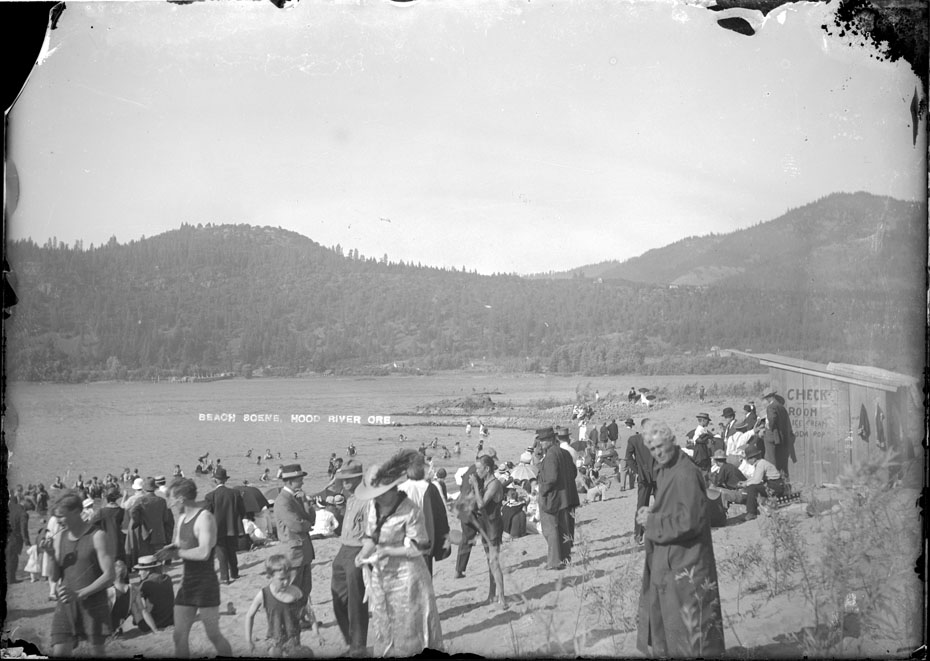
Early this summer I promised some more images of the “not Koberg Beach” beach so we could definitively identify its location. Today’s Mystery Monday assignment, should you accept it, is to take a walk along the waterfront with this image and identify exactly where the hills line up to produce the background we see here. With Strawberry Mountain and Hospital Hill it shouldn’t be too hard. Remember most of the waterfront is fill, the river level is higher due to the dams, and it’s not safe to stand in the middle of I-84 traffic even if it is the ideal vantage point.

Charlott
Definitely can tell where it was. I noticed the hook type piece of land, which naturally would have been lost when Bonneville was built. Even though Koberg’s was somewhat of a ways up river, this piece of land may have sort of protected Koberg’s from the aggressive under tow that was and naturally still is present. Ofcourse, that piece of land may have been constructed to protect that beach area. Probably will never know if it was put there or natural.
Would it not be interesting to know about the older fellow in his "duster" type coat. Maybe protecting himself from the sun, early "sun block" method.
Must have been a great socializing place for the people of Hood River and Hood River Valley on a hot summers day.
l.e.
I thought at first the coated gentleman was a priest. I can see Dock Grade on the Washington side coming down to the dock landing.
l.e.
In the early cyanotype photo of downtown HR, I was surprised at the lack of trees on the Washington hills above the hospital.
After looking at this photo I think it must be a result of different seasons.
You have a Columbia River Flood 1948 photo that appears to be taken from almost the same spot.
I84 is the ideal advantage point for many of your photos. I often try to visualize what the scene would be like to be standing on a boat, pulling into the bank at HR. but I am too busy entering and exiting I84.
Connie
This almost looks like an early "Roy Webster" swim type event. It seems that everyone is coming out of the water and the people on the side appear to either have just come out or are dressed to be standing and watching people come out. Is that possible do you think? Maybe the guy in the coat just put that on over his swimming attire to stay warm after being in the water?
Charlott
Apparently the check room was a place that you could leave your possessions while on the beach?
Some even wore their "Sunday best" to go to the beach…..
Arthur
Not only a check room, but ice cream and soda pop! Most of my childhood beach memories involve too much sun and ice cream sandwiches with a little windblown sand.
Esther Smith
I found this in the June 29, 2005, Yesteryears "Ninety Years Ago" section (making it June 1915) which predates this photo a tad but seems to describe it well:
"With the arrival, at last, of the hot weather, swimming has become the popular sport. The present location of the bathing beach is in the cove just this side of the White Salmon ferry landing and each afternoon sees a score or two of boys and girls, young men and women disporting themselves in the water. A deserted dock is used for a float and diving boards are provided. Sunday the beach resembled a bit of Atlantic City with many bathers and spectators. As the water falls during the season the location of the bathing place is changed from time to time."
Esther Smith
A few weeks later (July 27 Yesteryears) I had another related entry:
"An effort is being made this week to organize a swimming club. This recreation has been extremely popular here this summer and every day recently has seen a large number enjoying themselves on the beach this side of the White Salmon ferry point. The beach at this point is sandy, gradually sloping and protected by the point from almost any current, making an almost ideal bathing place."
Ellen Dittebrandt
I would say this is about where the Best Western is now but of corse further out into the river. Maybe that little island was part of the beach.
Ellen Dittebrandt
There is another beach west of this point it looks to by the water treatment plant the Event site. You can see this on in the aerial of HR.
Dose anyone know if there was a building where the parking lot of the Elks Club is now?
Arthur
Ellen, by 1905 the Davidson Fruit Company had a box manufacturing plant at the location of the current Elks parking lot. It was vacant by 1916, and I don’t see any record of any building there after that.
When we do the high-res scan of that aerial view we’ll need to take a closer look at possible beach locations– good idea.
Ellen Dittebrandt
I am sure this beach is right on the left side of the Hood River Bridge. North of the Marina Parking lot. The beach looks to be in a north south direction just like the aerial you will see a small beach right next to the bridge.
Barbara Parsons
Boy, how long has it been since any of us have "disported" ourselves?