
Historic Hood River
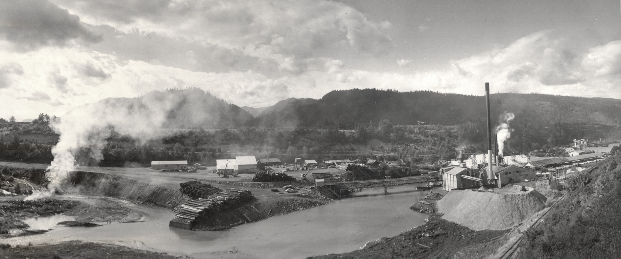
Dee Mill Panorama
11-17-2015
Notes

I know panoramas don’t work so well on this website, but this one is too beautiful to pass up. Last week a very thoughtful man dropped off a suitcase of photographs and artifacts, many related to the Oregon Lumber Company mill at Dee. It included a set of 12 panoramas of the mill operations. I’m estimating they are circa 1950. They were certainly taken by a professional. They are all composed beautifully. It takes a real professional to find the beauty in an industrial scene. Perhaps someone has seen this series before and can fill us in?
You can see this image with a little more resolution here. The actual scan has 100X the pixels of even that larger version, but it’s much too big to share.

L.E.
Thanks to the man who dropped off the suitcase of photographs.
I hadn’t thought about it, but this photograph has many interesting features to study, along with a beautiful background.
I guess that takes someone with a professional eye.
I don’t remember that much flat ground at Dee??
nels
When wood was king. Not even any wigwams.
andyB
So what direction are we looking? And where in relation to the current bridge?
If you go up river of the current bridge there is actually quite a bit of flat land on the west side of the Hood.
OrMtnMaid
This picture was taken near where the water tower sits on Dee Hwy. We are looking Northwest. The road on the other side of the river is the road up to Dee and the old school house is just off the left side of this picture up on the flat. Compared it to Google Earth historic pictures to come to these conclusions.
L.E.
So….if we are looking northwest, does that gap in the hills lead to Greenpoint?
And if so, would the Greenpoint flume ,which we have seen in HHR photos, have come down through that gap?
Arthur
That may be roughly the direction of Greenpoint, but the flume went in a completely different direction. It went to the NE from the mill, towards the Belmont Rd/ Country Club Road intersection. You can see this location and the flume route on this map: http://www.historichoodriver.com/image-swipe-master/lower_valley.html
Kenn
LE, the flat ground is still there and drivable, an interesting place.
James Holloway
LE, thus Dee Flat….! The gap in the hills leads off in the Lost Lake direction, I think. Off to the north there is another gap, Greenpoint Creek that way, I believe…
J.E. Sheppard
There is no trace of the old Dee company town that used to crowd up to the east side of the river canyon. Likewise, there is no trace of the old cabin camp that used to hang on the west wall of the canyon. I think that bridge is in place for the bull chain to pull in logs from unload & deck on the west side of the river, and the round roof of the hardboard plant is visible way down there. The covered bridge is also gone. I’m just guessing now, but I’d say this was the J.H. Hines mill by time of this picture, maybe 1960’s.
Arthur
In one of this series of panoramas there is a sign above a door which says "Oregon Lumber Company Hines Plant". The cars in the series of images all look to be 1950s. According to the Oregon Encyclopedia the Hines Lumber Company purchased this mill in 1955. I wonder if the panoramas were commissioned for that occasion?
J.E. Sheppard
I got my "Hines" mixed up. This was the EDWARD HINES mill, not the J.H. Hines. J.H. was a soldier in the civil war, confederate side, who is somewhat revered in parts of Texas, though there is apparently no record of why. Then there’s the bottle of Hines ketchup; it’s none of those folks either. Edward Hines Co. put together a sizable timber empire in the mid 20th century, of which the Dee Mill was one entity.
After I wrote it, J.H. just didn’t sound correct…
Jimmie Barber
My Grandfather ( Elmer Hausinger). He helped build the old plywood mill known as Champion Hardboard back in the early 1950’s. He was the lead Millwright there until 1970. I knew that old mill real well and almost everyone who worked there I’ve some great memories of that old mill.