
Historic Hood River
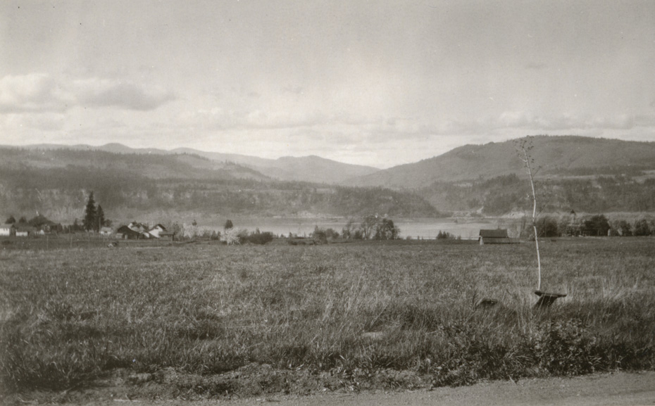
View from May Street
4-3-2015
Notes

My first guess when I saw the caption “view from May Street” was that this was from somewhere west of Rand Road. But trying to line up the hills in Google Earth, my best guess is it’s much closer to the position of the current Hood River Middle School.

Charlott
Shows just how far we have progressed….
Rawhyde
the middle schools campus is slopped though…
L.E.
The hospital is almost directly across from the mouth of the WS River. This appears to be farther west than the location of the middle school so my guess is the area of Rand.
Nice day for someone to take a bicycle ride and check it out. Except we have progressed so much, we might not be able to see anything.
Have we seen that home with tower before?
L.E.
I was thinking of the Adams house in photo #728. Not the same shaped tower.
L.E.
Hmmmm, if this postcard is anything to go by, I am wrong about the hospital being across from the mouth of the WS.
https://www.hoodriverhistorymuseum.org?showimage=653
I sure thought I could remember standing in that upstairs visitors room for a lot of hours and looking at the White Salmon River.
Dan
I feel like May St. between Frankton and Rand has about the same topo as Rand Rd. itself. I don’t think there is any flat area as seen in this photo north of May St. This looks like it further south up the hill from May St. such as Fairview.
Longshot
Maybe a view from Belmont looking over the area where May Street and the Middle School are today?
https://www.google.com/maps/@45.701798,-121.529867,3a,75y,350.98h,88.46t/data=!3m4!1e1!3m2!1scLxlqCfrjPaFqpm_m8r2jQ!2e0!6m1!1e1
L.E.
Dan or Arthur….I just opened my lap top and for my screensaver I have a photo taken by Big Tom who posts at the weather site. It is taken from the area of his home, looking toward Mt Adams.
Sure looks like this spot.
I have no idea how to get to his blog, but I bet the photo will be on there. Grassy field….some trees in the way now
Jon
Looking at the small peak directly over the mouth of the White Salmon river. A line through them intersects with May at about 18th:
https://www.google.com/maps/d/edit?mid=z3awyQE6ljA4.kV6IDvrOpJqE
Am I identifying the correct peak?
Longshot
Actually in order to see the river from the May Street area, you need a fairly steep hillside. Looking down 13th street at May you can see the river, while in many other places further west along May you can not even if the trees and building were not there. Using this info, I would say that the picture was taken fairly close to the Middle School location.
L.E.
Interesting map Jon. Kind of puts it right by the HR Middle School, doesn’t it?
I suppose that means we should not have doubted Arthur’s conclusion.
The name of that peak is Bald Mtn.
This is the photo I was referring to.
http://oldfartcoders.com/?m=201308
L.E.
I forgot to add, that I was driving home last night on Highway 14, looking across the Columbia River trying to place where this photo was taken from. The Columbia Gorge Hotel is definitely too far west and as I got closer to the WS River, the Old Hood River High School was becoming a logical choice.
The National Register of Historic Places for the "Historic Hood River High School" says….
"The Hood River High School was built in 1927 …….
The ….. School is located on 17th and May streets (tax lot 6500, Adams Paradise Acres) and is sited on the north shoulder of a hill commanding a view of the Columbia River and Mt Adams to the north. The building was constructed on a nine acre parcel bounded on the south by May Street, west by 18th Street,……
The property was part of William Jenkin’s Donation Land Claim…..and was later platted as Adams Paradise Acres……
The water source for the site was a spring at the county’s gravel pit located nearby at about 18th and Taylor streets. The water was piped from the spring, downhill to the school site……"
So…perhaps that is the Adams home on the right.
The residents of Hood River definitely have a beautiful school in a beautiful setting.
dayne
My house is just west of 18th st. below Cascade Av. I can see hwy 14 out my kitchen window everyday. Straight across the river and and a couple hundred yards east are the buildings along the highway west of the White Salmon River. I would confidently suggest this picture is along May St. looking over the future subdivision just west of the Middle School. Probably around 20th