
Historic Hood River
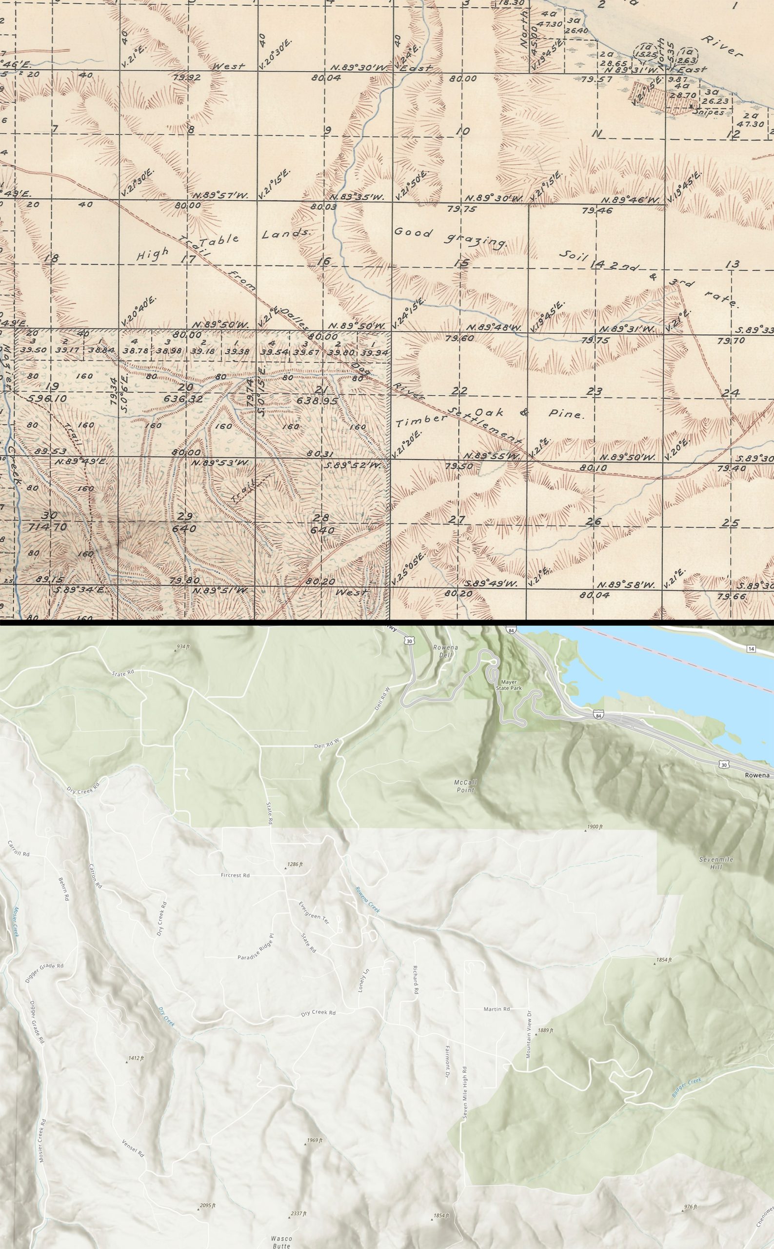
“Trail From Dalles to Dog River Settlement”
Notes
I can’t resist a good map, and this one provides evidence of an important piece of local history.
The 1850 Donation Land Claim Act started a process of mapping and “claiming” lands across the Oregon Territory. Of course much of the land was already occupied. The area near the Dalles had been a local trading area for thousands of years at this point, but in February 1860 Daniel Murphy, under contract with the General Land Office in Oregon City, surveyed Township 2 North Range 12 East so people would know where the resources were: trails, creeks, good timber, grazing land, good soil, etc. I’ve looked at dozens of these maps, but this is the only one I’ve seen which confirms the story that the Hood River settlement of the Coes in 1854 was really called “Dog River” originally. Later in 1860 when another surveyor mapped that settlement it was recorded as “Hood River”, so the name change probably happened pretty close to this date. News didn’t travel very fast back then so we can’t be too definite about the timing.
The story which has been passed down is that Mrs. Coe didn’t like the name “Dog River” and suggested one she thought was more pleasing. It’s nice to see some contemporaneous evidence for the timing of this event. If you’re wondering why she didn’t choose “Waucoma”, the purported native name for the site, the evidence supporting that name is very weak. I’m working on another post on that subject, but my working theory is the word “Waucoma” was actually imported from the midwest later in the 1800s. There are plenty of published accounts about the origin of the name “Waucoma” but I have yet to find one accurately citing a contemporaneous account or legitimate linguistic analysis.
This map shows the chunk of land we now think of as the Rowena plateau. Rowena is at the upper right, and Mosier Creek is at the far left. These maps are always full of wonderful details. For example, you can see cultivated land with a house (black dot) and the name “Snipes” where the town of Rowena is today. I’m not sure if this was Ben Snipes (good story at that link) or perhaps his brother George? Hopefully some of the historians from the Dalles can fill us in.

L.E.
I think George Snipes at Snipes Pocket.
https://shellerstories.wordpress.com/wagon-train-bride/
Arthur Babitz
“Snipes Pocket”. The story and the map are a perfect match. Thanks L.E!
Susan Baldwin
If not mistaken, Jim Clair (Hershner & Bell Farrell insurance agency, now known as Columbia River Insurance) once mentioned that his wife Debra is a descendant of George…
Arthur Babitz
Pat A. forwarded a picture of an old stone house with a plaque saying “Built by LT and Geo Snipes US Grant 1854”. I take this to mean LT and George Snipes built the house on an 1854 Donation Land Claim. Does anyone know who LT Snipes was? George and Martha Snipes had twin boys Leander and Lester born in 1855. I suppose this house could have been built when they were older. I don’t have a middle initial for either son.