
Historic Hood River
End of the Flume
9-30-2013
Notes

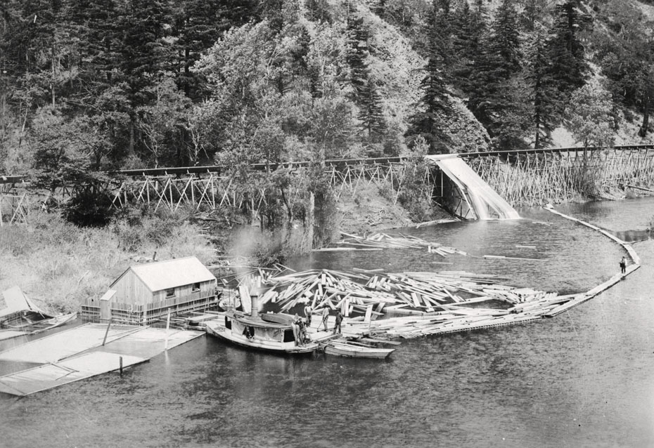
Here’s the end of the Oregon Lumber Company flume at Drano Lake. The logs were rough sawed at the Chenowith sawmill, and are now halfway through their journey to become dimensioned lumber. Tomorrow you’ll see how they got across the windy Columbia to be turned into dimensioned lumber for markets served by the OR&N Railroad.
Category: default
Tags: boat, flume, Little White Salmon, logging, lumber, Oregon Lumber Company, ship, Viento
Tags: boat, flume, Little White Salmon, logging, lumber, Oregon Lumber Company, ship, Viento

spinsur
So, this would be about where the road along the Little White to the hatchery is now (other than the river height change due to Bonneville)? Interesting that they built a fence along the sides of the houseboat. Should have been a rather protected location if tucked along the west bank. And that appears to be an outhouse? Gee, wonder where it dumps! If the water slide is where the cants fall into the pond/river, why would the flume continue?
l.e.
Are we looking at the east side or west side of Drano?
I appears that the right side of the flume is higher than the left which would make it the west bank, but I’m not sure.
From Chenowith, I think the flume would come down the east side.
I have two little books on the history of the area so maybe I will learn something about the flumes.
I did read that there was a store at the mouth of Drano. On the east side on ground that is now under the Dam water. The flood of 1894 washed it out.
spinsur
Well that’s kinda what I was wondering l.e., if the pic was flipped, that would explain the fence better. Take a look at google earth. There’s a track down to the water on the east bank of Drano, but I’m not sure I can make the rock work. And the protected bay on the west side looks good.
Ralph
One can currently observe visable remains of a flume on the east end of Drano lake. It’s elevation is much greater that the one in this picture especially taking into account the river level is much higher now then what is shown in the picture. Any ol timey explanations?
spinsur
That’s the more recent flume, from Mill A to the Broughton Mill on the Columbia. Infamous from Lassie days, and as much as possible removed under Scenic Area demands.
longshot
Lots of stuff falling apart in this picture. Some kind of structure on the left tumbling down with a sunken boat in front of it. The dump for the slide is partially collapsed. I wonder what the awash platforms are to the left side?
I would guess that the flume continued on out of the picture to take cants to another holding area we can’t see.
The upkeep on the flume must have been tremendous.
Some of the trees looked flagged, so I would say west is to the left of the picture.
Randy
I’m thinking we are looking at the south bank of Drano Lake, in the same area that the log rafts have been tied off for years, this would be where the lake makes the bend back to the east towards Tunnel #5. Some of the rock outcropppings and shading in the picture look to be a south facing slope. The flume could have continued on to the later designation of Broughtons Mill or emptied into another collection point on the columbia river.
Buzz
Previous photos made sense to me and looked like a well organized outfit. This one leaves me with nothing but questions. Spent a little time rafting logs and towing rafts to mill, and this looks like one haywire operation. So will just accept the fact that it worked and see what tomorrow brings.
Scott Cook
Arthur showed me this photo a couple months ago and I’ve pondered it since without figuring it out. This doesn’t look like any sort of permanent operation at this site. Perhaps something had happened to the "real" end of the flume?? Also, my main question is where was this photo taken from? The RR embankment was a decade later…so when I try to imagine where this photo was taken from, I draw a blank. Ideas??
spinsur
Scott, I don’t have a way of offering a link, but the Army Corps map of 1937, R-0-17-10-WS, which I realize is long after this pic, but shows an existing finger of land, that6 the railroad was built upon, substantial enough to have pasture and willows, with the Government meander line a fair ways south. It may be the picture was taken from there towards a "log dump" on the west bank. No flume shown or labeled that I see.
l.e.
I am going that direction today, so with photo in hand, I’m going to drive up toward the hatchery.
With the cottonwood tree and the low ground, I was thinking this might be up by the hatchery, but it is so close to the water, it must be near the mouth and of course, the mouth looks nothing like it used to.
Here are two links to some online history of the Willard/Mill A/Chenowith area.
They might help solve some of the mystery.
The Willard Story:
http://www.columbiagorge.org/wp-content/uploads/2013/06/Willard_History_of.pdf
The Little White Salmon and Mill A Memories
http://www.columbiagorge.org/wp-content/uploads/2013/06/Little_White_Salmon_Valley_Memories.pdf
l.e.
Hopefully, as Arthur continues his photos we can get some accurate dates for the history of Drano.
Arthur says the photo album has a date of 1897.
History for William Drano, "French Billy" was issued a land title in 1896 and bought out by Broughton.
A quote from Columbia River Images.
According to Keith McCoy (1987) in Mount Adams Country: Forgotten Corner of the Columbia River Gorge":
"… William Drano, known as French Billy, organized the Drano Flume Company to build a flume which traversed much of his homestead land. Underfinanced, the firm got into trouble and was bought out by Broughton Lumber Company. They not only completed the flume but it has served for 70 years – the last of the great flume mills. …"
I have read that Drano’s flume went across his property to Drano Lake.
spinsur
The map I referenced above does show a flume, almost off the map northerly, not shown by the river. By the time of Bonneville, the property is shown as "Cazadero Real Estate Co. and P.R.L. & P. Co."
Arthur
Sorry I can’t resolve any of these mysteries. I checked the source to see if there was any text so I could determine if the negative was flipped– but no luck. None of the four boats (count ’em) in the frame has a name painted on the hull, and there is no text on the building. All we have is a rough date of 1900 and the text which I shared last week.
spinsur
Five boats! 😉
Arthur
I didn’t count the half-submerged one. Is it technically a boat if it doesn’t float?
Chase
If this is indeed Drano Lake, then I’m of the opinion that it was an early version of the Broughton Flume, which, at its terminus, would have been configured differently than what we can now see of the flume and where it was headed. I’m sure the flume had many configurations over the years due to fires, storm damage, etc. Later versions of the flume went higher up the hillside.
spinsur
I’ll leave that to the moderator!
Buzz
Was the U-Boat in WW II a boat.
l.e.
There is a plaque at the Drano boat launch. One of the photos shows what is probably the first hatchery and a flume. I couldn’t tell if the flume was for logs or fish. In the photo you can see the river continue down stream.
If this photo is on the west side of Drano, I suppose it could be at the mouth where a little point kind of makes an island.
But I think Randy’s identification is pretty accurate.
l.e.
Perhaps the flume continues on to accommodate the constantly changing seasonal river level.
Harold D Broughton
The Drano Flume and Lumber Company was built by my great-grandfather, George Broughton and his business partners. This is a new picture I have not ever seen. I do have the original pictures of George’s crew working with him building the flume down to Drano Lake. Not sure where William Drano comes in? I was very told he was a partner. My grandfather, Harold J. Broughton and his original partners (it was not DM Stevenson) bought out the flume company and formed the Broughton Lumber Company in 1923. The flume had started running in 1913. There are a few missing pieces to the history of all of this and I would like to know more:) Thank you.
Jack Sheppard
I recall that at a time near the end of the flume operation, a spokesman for Broughton Lumber stated in the H.R. News that operation of the flume over it’s lifetime delivered lumber to the Columbia river mill site for $0.02 per/ thousand board feet. If that is correct, and if I remember it correctly, that’s a heck of a bargain for transportation!
L.E.
From the August 29, 1896 The Dalles Times Mountaineer pg. 4
"Charles Early, of the Oregon Lumber Co., was in the city last night. On his return home this morning he took with him to Drano a large consignment of fruit and cantelopes."
Jennifer S Keller
My grandfather was good friends with Harold J Broughton, they had a long standing weekly lunch date. His name was Clarence Jewett.