
Historic Hood River
Rockwood, Oregon
9-5-2013
Notes

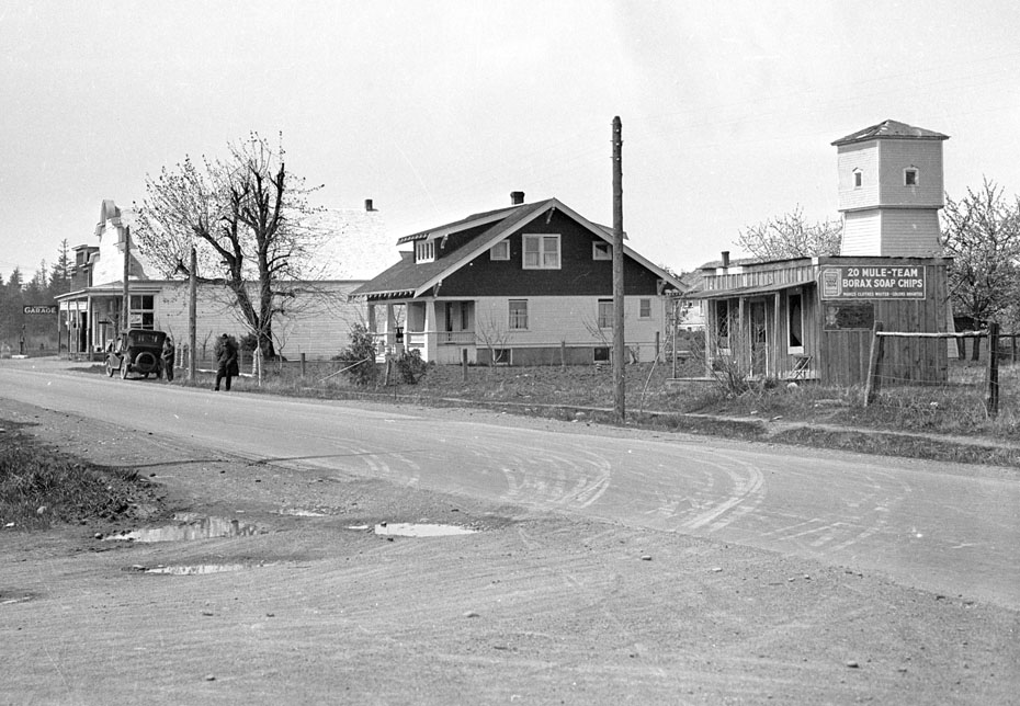
Rockwood is now in the middle of Gresham, but in the 1920s it was a small cluster of shops. Check out the billboard for “20 Mule Team Borax Soap Chips.” It promises to make your clothes whiter and colors brighter.
Not sure why Alva Day was visiting. Perhaps he stopped for gas.
Google identifies this spot as Rockwood today.

Charlott
Nice image of both water tower and false fronts on buildings. Must have had a rain shower, due to mud puddles.
Gives somewhat of a good view of three generations of buildings.
l.e.
Who knows why Alva Day takes some of his photos.
But I am glad he did because they are interesting to us today.
If he took a photo of this, I would assume he would have taken a photo of the Stark St. bridge that crosses the Sandy.
This is probably his route for coming or going home from Portland to HR on what we now call the Old Highway.
My husband’s grandparents lived on Government Island and at one time, in order to vote they had to row across the river and then walk to a polling area just north of this photo.
l.e.
I was going to ask if it was named for rocks in the wood or woods in the rocks.
Wikipedia gives some history: Milepost 10 at a rocky, wooded area.
http://en.wikipedia.org/wiki/Rockwood,_Gresham,_Oregon
Since those two men are parked and standing in front of that house, it makes you wonder if the house was the focus of the photo.
spinsur
From l.e.’s link above: In the late 19th century, a stone marker was placed every mile east of the courthouse in Portland, resulting in a "Base Line Road" along the Willamette Baseline: Rockwood developed at the 10-mile mark, in a rocky and wooded area that was later the inspiration for the name of the community.[3] A Ten-Mile Inn located in present-day Rockwood became a stagecoach stop, a junction that also attracted a school, a grange hall, a church, a grocery store, among other businesses.[3]
So, Baseline Road, on the Willamette Baseline, the same as our Baseline Road in Parkdale, is on Stark Street, which would seem to imply that the photo is looking at present day Stark. Most folks would know Rockwood as the location where Burnside and Stark cross, now with the light rail. And interestingly enough, it’s Burnside that splits Portland north and south, not Stark (baseline)!
l.e.
Is there a stone marker in the front yard of the home?
Also another reason Alva Day might have stopped in Rockwood to take a photo….reading some history….it was known for moonshine.
spinsur
If you’re looking at what I’m thinking you’re looking at, look further away, behind the car, I think you’ll see two more, look like gate posts, so I took the other lone one to be a fence corner post. Any mile markers or GLO corners on the baseline would be near centerline of the road. Appears to be winter, and IF it’s baseline/Stark, by shadows buildings would be on north side, and we’d be looking westerly mid day.
l.e.
Type your comment here.
Good analysis.
Jill Stanford
I have learned more, here, from all of you than all my years of schooling!
🙂
l.e.
Here you go spinsur:
The Stark Street Mile Markers
http://starkstreetmarkers.blogspot.com/
l.e.
I should have noted that the comment section contains a map of the mile markers.
https://maps.google.com/maps/ms?ie=UTF8&oe=UTF8&msa=0&msid=106421195866702755353.00047529951e047ac1e4f
The one at Mile Post 10 Rockwood is missing.
Brian
The post to the right of the closest person sure looks like a milepost marker. There’s a post in the Parkdale Bicentennial Memorial Garden that also looks like a milepost marker. I’ll check it out better the next time I’m there.
Arthur
I checked the detail on that post– it is made of smaller river rock stacked and mortared. It matches the other fence posts next to the car, so I don’t think it is a milepost marker.
Ellen Hawkins
Can anyone tell me what used to be in the area of 174th and Stark?
L.E.
Not the same home, but this June 25, 1916 Sunday Oregonian talks about improving Baseline Rd. as a beautification project for the Columbia Highway.
http://oregonnews.uoregon.edu/lccn/sn83045782/1916-06-25/ed-1/seq-12/
Laurie(Brownawell)Wiezorek
@ Arthur 10th September 2013 What used to be in the area of 174th and Stark?
I grew up in Rockwood during the 60’s and 70’s when Stark Street was two lane. It became 4 lane in the early 60’s.
On the northeast corner of 174th and Stark was the Meyers Motel. It was green in color. Had their house sitting on the corner and motel was L-shaped behind it. They lost part of it when Stark Street was widened to 4 lane.Later the house was torn down and the motel part was made into a business strip mall. The only motel left on Stark St is Fir Haven. I haven’t been back for two years, so that maybe gone now. There used to be quite a few motels on Stark St. My parents owned one at 196th and Stark St, where Kaiser Clinic is now.
Larry Clark
The house in the photo was moved to the corner of 168th and Stark st in 1959, My father bought it and we lived in it till 1962. I attended Rockwood school 1959 – 1962.
Mike Kern
Close to 174th and south side of stark at one time in the late 50’s was a large chicken/egg production business owned by Al and Inez Bastron and their two sons Bill and Ron.