
Historic Hood River
T3NR10E
Notes
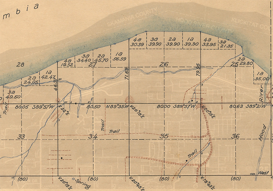
When Oregon became a state in 1859 it created plenty of work for surveyors. The new state was divided into “townships” (each 36 square miles) starting at the Willamette Stone near Portland, and hand drawn maps like this were created, each one named based on how far north or south is was from the “Willamette baseline,” and how far east or west it was from the “Willamette meridian”. Most of the city of Hood River fits in T3NR10E, the third township north of the and the tenth range east of the Willamette Stone. This township map further divides the territory into 36 numbered “sections,” each of which is divided into four “quarter-sections.” I’ve cropped this map to highlight the more populous portion of the township.
Because we still use the same system to describe and number sections today, you can fairly precisely line up this 1860 map with a modern map. I am always experimenting with ways to present old maps along with modern ones. I’ve tried “swipers” like this one that let you swipe between old and new views, and I’ve tried lining up old and new views like this post from last week. Today I experiment with a little Photoshop magic: While we mainly want to focus on the beautiful 1860 map, I’ve embedded the modern view, in negative, so you can get a sense of how these 1860 features relate to our modern world, hopefully without the modern version being too distracting.
White settlers had only started homesteading in the area eight years prior to this survey, though of course Native Americans already lived in this valley. The 1850 Donation Land Claim Act creating a motivation to settle on “unclaimed” land to make it their own. We know by 1863 there Donation Land Claims by Nathaniel Coe, William Jenkins, James Benson and Nathan Benson. This 1860 map shows only 4 houses, though there were others. I can see the cabin Dr. Farnsworth built in 1852 at what became Dr. Adams Paradise Farm, though not William Laughlin’s cabin which Nathaniel Coe took over and built a house next to. There’s one house in the Frankton district, another on Indian Creek near Brookside, and the final one on Phelps Creek near Frankton Road.
The few scratches of roads and trails indicate where people were traveling. You can see the rudiments of Tucker Road and Belmont Street taking shape.
Identifying the Columbia River shoreline in the 1860 survey map can be a little confusing because a broad extent of seasonally submerged land is shown (as it was used for agriculture and eligible for land claims). What looks like a river running east-west is actually the Columbia River slough. If you follow Phelps Creek across the map and over Wau Gwin Gwin Falls to where it merges into the Columbia River slough it will start to make sense. You can also see the path I-84 cuts across the map, marking the northern boundary of year-round dry land.
Tags: 1860s, 2010s, Baseline Road, Belmont Street, Coe, Frankton, Frankton Road, Laughlin, map, survey crew, surveying, Tucker Road

L. E.
Growing up on the west side, I was somewhat familiar with the term “Baseline Road”, from Portland out to the Sandy River.
Imagine my surprise when I moved to the east side, and went out to Parkdale to pick strawberries on Baseline Road.
JEC
Did the Donation Land Claim Act designate section 36 of each township as the school section in each township like the later Homestead Act?
Arthur Babitz
JEC, here is the text of the act: https://pages.uoregon.edu/mjdennis/courses/hst469_donation.htm
It has a provision exempting sections 16 and 36 from claims, though I don’t see any explanation for this limitation. There is also a provision for the legislature to reserve two townships west of the Cascades, one north of the Columbia and one south for university purposes.
LWH
Dukes Valley is identified on the older swipe map. https://www.hoodriverhistorymuseum.org/historic-photo-resources/image-swipe-master/lower_valley.html
Arthur Babitz
LWH I checked the 1860 map for township T2NR10E– no Duke’s Valley on that one. There is a “Butler’s Ho.” with a structure marked on Odell Creek, but no mention of Duke.
Kyle
That Belmont-ish trail goes through the neighbor’s yard behind my house, more or less B Street… Fascinating.