
Historic Hood River
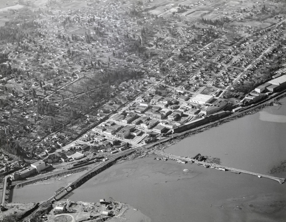
Hood River Aerial View
12-7-2017
Notes

I can’t date this one precisely, but I think it’s from the late 1940s or early 1950s. The 1954 County Courthouse is nowhere to be seen, I-80/I-84 isn’t there either, but “the Ruins” is already in ruins, Hood River High School (now Middle School) is inplace. Hood River Distillers (established 1934) is at its location at the east end of State Street. It looks like the vinegar factory and the creamery are still operating. Any ideas on how to more precisely date this image? I can’t think of any major changes in this era to date it definitively.
[Ed. Note: Based on the construction of the Elks Lodge at 3rd and Cascade we can date this image to late 1948/ early 1949.

Buzz
Moved to Hood River in 1955. Never heard of "The Ruins". What are they?
Charlott
It has to be the 40’s because I am seeing locations where in the 50’s were structures. I also see the big old house on Button Hill. I do see the brick building that house Oregon-Washington Telephone there on the corner where you go up Serpentine. Do we know when that was built? Is that the stable down there on the end of Oak Street? It could be even earlier than late 40’s.
Norma Simpson
I grew up in Hood River and never heard of "The Ruins" either!
Norma
I don’t see the house where my father first lived when he moved to Hood River in 1937. It was at the top of the steps coming up from down town. Looks like a vacant lot in the picture.
Longshot
Interesting that the Ruins were already in ruins at that point in time. Were they never completed, burned? What business was ever there?
Looks like all the east-west streets of the downtown area all had sidewalks by then running out to 13th Street or beyond
curtis
It looks like the Elks Club is built and that was in 49 or 50 and it is on the corner of 4th and cascade.
Arthur
@curtis is correct, the Elks Lodge is under construction in this view. It was dedicated June 6, 1949, so 1948-9 is the date.
"The Ruins" is the modern name for the shell of a cannery down by the rail depot which is currently used by Springhouse Cellars for concerts and events. It apparently burned after not many years of operation. I tracked down the rough chronology for the Springhouse folks a while back. I’ll dig it up later.
L.E.
Hard to get a perspective of where the freeway runs.
In this HR Delta photo. Arthur makes a comment about where the freeway runs.
https://www.hoodriverhistorymuseum.org?showimage=1068
I don’t know if it helps, but remember this "operation post" WWII photo?
No buildings.
https://www.hoodriverhistorymuseum.org?showimage=49
James Gray
I tried to see if my folks home on 7th and June was built yet 47-48 but the picture is to Fuzzy, looks like the old May Street School building is still there
Arthur
You’ll see a freeway construction photo next Monday.
The old high school on May Street was demolished in 1957.
The Fashion Garage at the base of Oak Street burned in 1929.
L.E.
Could we be looking at some 1948 flooding?
Not as dramatic as this photo, but I think that might be the same boom.
https://www.hoodriverhistorymuseum.org?showimage=71
cathleen
I wish there was a transparent overlay of what it looks like now, a current drone photo from the same perspective overlayed on the old photo. It’s almost unrecognizable.
Jeffrey W Bryant
I can see the Catholic Church at 7th and Montello. I’m trying to locate a better photograph of it.
Larry Bennett
Web site for his history.
https://flyingtigersavg.com/jernstedt-kenneth-a/