
Historic Hood River
Old Hood River Bridge
Notes

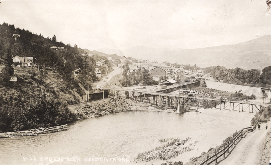
This view of the old bridge across the Hood River is rich with detail. There’s even a heavily loaded horse drawn wagon crossing the bridge, and you can just make out the blur of an automobile speeding across. Based on the downtown buildings this is circa 1915. If you look carefully you can see the Fashion Garage, the Rand Livery, the Mt. Hood Hotel (old and new wings), and the Knights of Pythias Building way up State Street.
I previously thought this bridge was constructed completely out of wood, but the detail visible in this scan makes it clear the main truss was steel with cross braced steel cables. It’s possible this truss was a recent addition, as we know the bridge washed out several times between 1900 and when it was replaced about 1920.

l.e.
It would be interesting to identify the owners of the different houses on the hillside and how many of the houses and downtown businesses are still present.
Interesting photo. I didn’t realize how much fill was put in for the railroad grade.
nels
What are the wood structures in the river on the left of the picture?
Arthur
nels, I’ll bet they have something to do with protecting the bridge from logs and winter debris. We know from photos that those wooden supports on the west end of the bridge were washed out on a regular basis.
nels
That is quite an imposing structure, or maybe two, on the hillside above town. Anybody have information on that?
Heather
The railway embankment looks like it would be really good at backing up the river during floods.
Kenn
This photo shows new fill to the present RR bridge which I believe has 1907 dates on the portals. I did not know the HR RR once had this much trestle below the road bridge that is now filled.
Compare this to the HR Columbia bridge, wood approaches do not have piling in water except for temporary false work.
l.e.
I think the wood structures in the river are some kind of dock. I know they don’t look very easy to walk on, but photo https://www.hoodriverhistorymuseum.org?showimage=392 shows them.
It even looks like there might be access from the Mt Hood RR.
longshot
Not only is the HRRR today on fill where it once ran on a trestle, but everything on the landward side has been filled to much the same level. It is really amazing how much fill has been moved in Hood River or in many other towns over the years.
l.e.
With the last few days having been in the 90’s, I can’t help but look at that road up the east side and think, "A miserably hot and dry walk!" How far up the hill before you could get a drink of water?
Charlott
I would think one would might we wise to carry their own jug of water, that would have been a real uphill grind clear to the top of Eastside Rd. My guess would be the closest water after you left the bridge might be Whiskey Creek up there where Whiskey Creek Road takes of of Eastside Rd. Maybe you could stop at some farm along the way at their well…..
Kenn
Seems there was a fountain on 30 east of the loops, any memories of this or is my imagination working over time.
Ryan
The house on the left of picture is actually 2 houses overlapping. The closer one is gone (now dentist office), but the one behind is partially sticking out – 215 Sherman Ave is still there. Just stayed there as a rental house, still in great shape!