
Historic Hood River
Motion Blur
12-14-2015
Notes

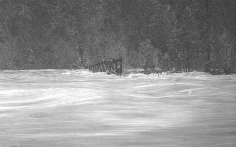
A while back I found a really poorly exposed photo of a washed out bridge with the Hood River at flood stage. I was tempted to Photoshop it to share it with you, but fortunately, like any good photographer, Alva Day bracketed his exposure so we also have this negative of the same event. The long exposure gives a wonderfully peaceful feeling as the river rages in full flood.

Kenn
The footings may have failed but this says much about the strength of wood bridge construction. Any idea where the bridge traveled from?
L.E.
Any idea what year?
It could almost be a snow scene.
Dan
I understand bracketing a photo in the digital age but how did it work with film?
Arthur
@Dan, in a shot like this you would choose an exposure and then shoot three frames– one at the aperture suggested by your meter, then one a 1/2 stop above and one 1/2 stop below. Maybe @Longshot will weigh in as he’s the expert.
Dan
Thanks Arthur, yea I get what bracketing is. Practice it all the time digitally. I was curious how it’s accomplished using film.How do you combine three or more pieces of film together? Oh, I think I just answered my own question- overlap the three frames in the darkroom?
Ranger
Could this be the penstock bridge for Powerdale? It washed out at one point in time and was winched back in place.
andyB
I was just on the pipeline bridge above the power house this weekend. It is all mangled and bashed up- it really took some abuse at some point. This looks a lot like the S-turn in that part of the river, and this looks a lot like that bridge.
i always wondered how that bridge could get its girders mangled right up to the top, which at normal water is about 25ft up..
What year is the negative from?
Arthur
You folks ask hard questions. Many of the Day collection negatives have dates on them, but at some point in their history someone took all those with dates and put them in envelopes by year, thus separating the ones without date from the context which might have helped date them. By the time Matt and I got the collection it was in a large shoe box with 2500 negatives in small bundles with rubber bands and little context. I looked at all Day images which we tagged "flood" to look for similarities which suggest they were from the same flood event.
I can tell you there are at least a dozen frames which seem to be from this same event. If I am correct in grouping these together, this image is not from the most recent Powerdale dam, but the previous one which was replaced in 1924 or so. There is a picture of the old wood powerhouse flooded, and a picture of the pre-1920 auto bridge washed out. This is the most "artistic" frame, but there are many others with additional context– the same wrecked bridge with a wider field of view. Based on my knowledge of the full collection I think this event was circa 1917, making them among the earliest in the collection which spans 1917-1955. If someone wants to search the newspapers I would start in 1917-1918 and I bet you’ll find the story pretty quickly.
I suspect @andyB is correct about this being the bridge which carried the pipeline across the river above the powerhouse. It looks too narrow for the railroad.
Arthur
December 20, 1917: http://oregonnews.uoregon.edu/lccn/sn97071110/1917-12-20/ed-1/seq-1/
L.E.
Thanks for the link Arthur.
The weather people say, Portland has had 10 inches of rain for the first half of December. The article in the December 20, 1917 issue of the HR Glacier says they have had more than 7 inches in one week.
The record high Portland temperature for December 27, 28 and 29 still stands for 1917. 61 degrees, 64 degrees and 65 degrees.
It must have been an odd December.
The following week, in the HR Glacier, (December 27, 1917) is an article that says damage on the East Fork was severe. The flood waters swept away the old Toll bridge which spans the East fork south of Mount Hood store.
That must be the site of Toll Gate Park?
Alva Day was in Alaska during 1917. He must have returned by December.
Kathleen
I have 5 photo postcards of a Bridge which I believe is either Oregon or Washington, on Dec 19, 1917 it was reported in the Oregon Daily Journal about extensive flooding from Hoquiam WA down to Albany, OR, several bridges were mentioned as being washed out. Also there was extensive flooding east, Yakima, Hood River etc .I can email pics if anyone would be able to help identify them
Captions read:
"Showing break in Bridge from the Kellogg Dock, Dec 19, 1917"
"Looking North from Kellogg Dock Dec 19, 1917"
" Looking East from Main span of Bridge Dec 30, 1917"
"East end of Main Bridge Jan 1, 1918"
"Bridge Flood Jan 23, 1919"
I also have 2 rppc of I believe the Hawthorne being built 1910