
Historic Hood River
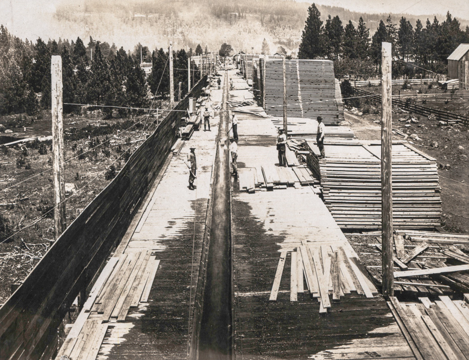
Stanley Smith Lumber Yard, 1906
12-12-2016
Notes

This is captioned “Stanley Smith Lumber Yard, Belmont, 1906” We know there was a planing mill near the intersection of Belmont Street and Country Club Road which was fed by the flume which came down from Greenpoint (Kingsley). The flume continued on to Ruthton. It’s really hard for me to place an operation this large at the present location of the Saddle Club.
Category: Downtown Hood River
Tags: 1910s, Belmont, Belmont Street, flume, logging, lumber, mill, Stanley Smith
Tags: 1910s, Belmont, Belmont Street, flume, logging, lumber, mill, Stanley Smith

Charlott
If someone could line this photo up with the Washington hillside, that might give a better idea just where it was located.
L.E.
Wow! Can’t wait to hear comments and ideas about this photo. I have a wondered how this flume worked. I had no idea it would have this large platform.
Dan Kleinsmith
Now that is a cool photo! I wonder what’s going on in this photo.
Dan Kleinsmith
I just realized that’s the flume in the center of the picture.
OrMtnMaid
It will be interesting to see where someone places this flume. It could easily be where Frankton Road currently sits near Krieg Millwork. Great picture. Lots of detail.
Arlen Sheldrake
as a former Belmont resident, I would also love to know what currently resides in this location.
this photo speaks volumes…….can you imagine the delay in shutting this system down if a problem along the flume or if these workers get overloaded with planks? can you imagine the conversations if one of the multiple "pullers" isn’t up to par and/or doing their portion of the work? must have been a pretty good team to get all the "planks" out before the end of the flume. talk about your production lines….no emergency stop here…the planks just keep on coming and coming….
where did the water go after being "flumed"? so many questions…….yet another great picture!
L.E.
Does this map give some information:
https://www.hoodriverhistorymuseum.org?showimage=892
Jerry, who sometimes comments here, has some old maps. Hopefully he will share.
OrMtnMaid
Wish the map link that L.E. furnished were clearer when zoomed in, but it shows this location as West of Country Club Road, East of Phelps Creek and South of the current Post Canyon Road between Belmont and Post Canyon Rd.
Arthur
The 1911 map shows it The 1911 map shows it about 1/4 mile north of the intersection of Belmont (then Church) and Country Club Rds, on the west side of the road. I can’t vouch for the accuracy of the map.
Arlen, there actually was an emergency stop if the flume failed. There was a spill gate up at the top which was kept closed by an electrical circuit. If the flume failed it would break the wire and the water would be diverted. I’m sure it still made a mess.
Charlott
If this was the flume that went down to Ruthton would it not have eventually had of have made a jog to the west?
Longshot
It must of been quite the job to heft a wet soggy board up onto the tops of some of the taller piles.
Just think of how many men had to be employed to keep an operation of this size going.
cg
So were actual boards sent down flumes? I had thought that only logs were transported in them. Were they planed at Greenpoint or was this done at Belmont and then reloaded to finish trip to Ruthton?
L.E.
Arthur, if you have the time, could you include the tag "flume"? Some of those photos have comments that might be of interest about this flume.
I gather this flume was originally a Davenport project?
Kenn
There were few log flumes, most brought cants down from rough cut mills such as Willard down to Underwood. This flume must have carried finished lumber as it is being piled for drying. A flume had to be very straight and gradual to carry logs or destruction would result.
An emergency exit for water such as Arthur mentioned can still be seen below Willard in case of a flume failure on the hill side. The water was diverted to Drano Lake and there is still a dock there for piling cants until flume could be repaired.
L.E.
There is no railroad here, so do you think the boards were stacked to dry and then hauled away by wagon? Those stacks are really high!!
If stacked to dry, they wouldn’t put them back into the flume down to railroad at Ruthton would they?
I think somewhere here at HHR in the discussions about this flume, there was a comment that a branch of it ran to downtown HR. I think the 1911 map shows that. What happened to that water?
Arthur
The 1911 map shows the flume ran N from here along Country Club Rd., crossing Phelps Creek just north of Post Canyon Rd. The Creek runs NE at that point and the flume jogs to the NW, ending at Ruthton near the railroad. We’ve seen several images of the end of the flume.
I haven’t seen any documentation of a branch of the flume headed towards downtown.
Arthur
Building on Kenn’s comment, the flumes above Green Point (from Rainy, Black and North Lakes) are labelled "Log Flume 4’x5" on the 1911 map. The flume from Green Point to Belmont and on to Ruthton is labelled "Lumber Flume"
L.E.
FROM THE SEPT. 20, 1900 HR GLACIER:
Davenport Bros. Lumber Co. are building a platform eight feet wide across the Rogers place at Belmont, which will be used for taking lumber from the flume to be sorted and stacked, until seasoned, or is wanted for shipment. The rough lumber can be hauled from this point more readily than from the planer to any point in the valley, or it can be sent down the flume to the planer to fill an order for dressed lumber. This platform will greatly facilitate work in the yards of the Davenport Bros. Lumber Company.
Another HHR photo #871. Looks like the flume is in the background.
https://www.hoodriverhistorymuseum.org?showimage=871
FROM AN OREGON HISTORY ARTICLE:
In the first decade of the 1900s, Oregon’s population grew by nearly two-thirds as the state’s economy took off once again. Wheat was the major crop, while timber barons like Simon Benson pioneered the technology used to wrest trees from remote hillsides.
It was a muscular world that produced awe-inspiring sights. In Hood River, for example, the Stanley Smith Lumber Co. built the world’s only level log flume, a humongous network of trip gates, holding ponds and sluice flumes that stretched for six miles.
Stever
Wow- well done ! – great added content and info everyone !
Jerry Larsen
I’ve been relying on the same 1911 map as in image 892, which the current County Surveyor gave me not long ago. I’m amazed at the size of this facility! My best guess is that the logs received at the Green Point mill were cut into the planks you see here, perhaps about 3" x 12," and then re-sawn and planed into usable dimension lumber at Belmont, with some of them continuing on to Ruthton, which also had a planing mill and a box factory. It appears that they’re placed into ricks for air drying before the final processing is done.