
Historic Hood River
Columbia River Highway Construction
4-21-2014
Notes

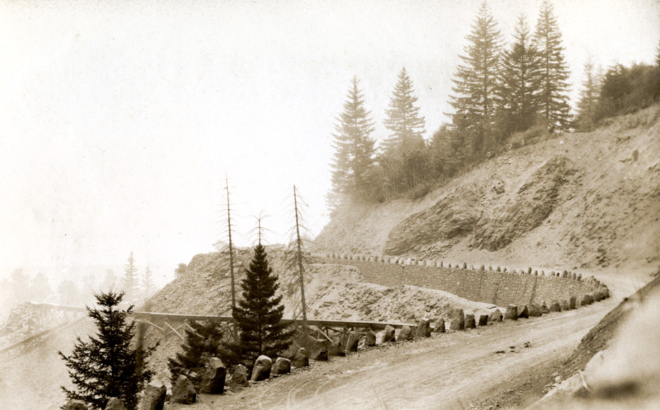
It’s time for another look at the Columbia River Highway. This image is from Ella May Davidson’s album. It must be during the construction, as the road is not yet paved. I particularly like the rockwork, included the pointed rocks to delineate the edge of the road.
The flume has me stumped. Any thoughts?

charlott
Hard to imagine the work that went into building that road. Wonder if the workers were to come back for the modern view of 84 what there comments would have been.
Who knows where this was located, but sort of looks like it could be down there on the uphill curves above Starvation Creek, where the slide was.
How would you like to come up through there in the dark?
Buzz
Maybe flume used to channel water away from the immediate side of the road so it wouldn’t wash away. If so must be a pretty good sized stream coming off the mountain and running through a culvert under the highway.
l.e.
Looks icy.
Buzz is probably right about the flume diverting water. My first thought was for mixing concrete, but why would you mix the concrete way out there away from the rock work?
For some reason this photo seems to emphasize the labor put into building this road.
l.e.
What is the dark stuff in the middle of the road?
charlott
Horse stuff???????????
Kenn
Possibly from Bridal Veil bridge. The bridge had multiple flumes beneath it, supports of one still exist next to bottom of falls trail, Flume in photo is level enough to lead to the water tank just below highway 30 on the right curve. This tank is about 30′ diameter and the remains can be seen and accessed from highway shoulder.
Arthur
I checked the full-res scans, and Charlott is most likely correct.
Longshot
Looks like a board flume to me.
A geologist might be able to pinpoint the location from the rockoutcrop in the road cut.
The road actually looks too narrow for the Scenic Highway to me. Could it be another road? Maybe a road on the Washington side of the river? The trees aren’t very big either, which would lead someone to believe the picture was not taken in the gorge at all.
AndyB
The flume may be totally unrelated to the road construction. It might have been there before, bringing water to someones mill, and they had to work around it.
Jill
I have been told that many of the (mostly) Italian workers who built the stonework and the Scenic Highway came to Central Oregon after it was done and built the dam that, in the end, was a failure in Tumalo. The dam is still there, but the water did not fill as hoped because of lava tubes under the ground. The campsites where they lived while working are "protected areas" near the dam – lots of rusted tin cans and bottles.
PK
Clarence E. Mershon’s book "The Columbia River Highway" has 2 photos along with a description of construction of a rock retaining wall and box culvert near Bishop’s Cap. The layout is excitingly similar. The box culvert was built to take a small stream under the highway. Even the rock capstones are similar. See p 128 in the book
Arthur
Robert Hadlow with ODOT thinks this is "the curve just east of the Bridal Veil Bridge before the county or state built the guard wall in front of the guard rocks. If you look there today, you will still see the guard rocks behind the guard wall."
Kristen Stallman with ODOT says the flume is for the mill below. We have a nice postcard of the Bridal Veil mill for a future post.
If you look at this spot in Google maps you can see many of the features in this image. The vegetation makes it a little hard to be 100% sure, but there are several details which match well: http://goo.gl/maps/mdFEp
Buzz
Do we know if the flume just carried water to a tank for a mill, or did it carry lumber and logs too?
Arthur
Someone sent me a nice image of this flume/road from the other direction. The flume comes from under the Bridal Veil bridge (behind us in the image above), runs along the roadside for a while, then heads down towards the mill as shown in our image.
This particular image shows a vehicle that’s run off the road and come to a stop wedged up against the flume. Obviously those guard rocks don’t do much to stop you from driving off the road.
Longshot
Using Google Maps, I was able to find the same rock outcrops several hundred feet to the east of Bridal Veil Creek. It looks like the road alignment may have changed a bit since the picture was taken, or maybe the original photo was taken with a telephoto lens foreshortening the appearance of the curve. This could account for why the photo shows the road climbing as a bit compared to the flume, while Google Maps shows the road being nearly level. Still don’t think the picture shows a 20 foot wide roadway, so the road may have gotten some widening between the time the picture was taken and when it was paved.
Ellen Dittebrandt
I just went there today. Arthur is right it is just east of the bridge. The rocks that lined the road are still there, they are on the other side of the newer arched rock guardrail. You can see that the road has been widen. The flume held ruff cut wood from the saw mill up Bridal Vail creek in a mill town called Palmer. Palmer was a mile up the creek. The flume delivered down to the town of Bridal Vale part of the same lumbar company town. In 1936 when Palmer Lumber mill closed down, that was the start of the end of Bridal the town.
Ellen Dittebrandt
I also saw what looks to be a Old wooded platform near the flume route. It is round. so I am guessing a water tank?
spinsur
Used to be able to four wheel drive to Palmer. Hunt bottles and glass amongst the neatly arranged, moss covered foundations.